Published :
Updated :
 For all latest news, follow The Financial Express Google News channel.
The government has taken initiatives to make Bangladesh's digital land management system more transparent, accountable, and accessible to citizens.
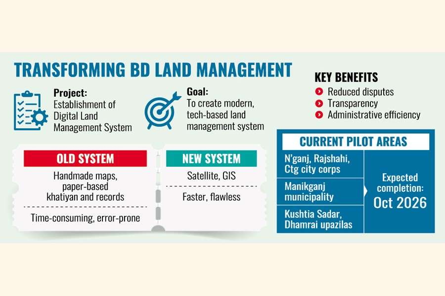
As part of that, the land ministry has undertaken a project titled "Establishment of Digital Land Management System (EDLMS)" to digitise the land management system in order to keep up with the technology-driven world.
Project Director (Joint Secretary) Md Mominur Rashid has told The Financial Express that EDLMS is an initiative taken by the government to ensure a modern, technology-based land management system, which will open a new horizon to provide faster land-related services.
The role of information technology is inevitable in the current era to bring public services to people's doorsteps, he says.
It makes the process smarter, transparent, and people-friendly, he also says.
The project director says EDLMS will resolve all land-related complexities and determine the proper demarcation of land and real land ownership, while also ensuring the optimum utilisation of land.
One of the biggest benefits of digital land surveying is the accurate measurement and preservation of land records. Previously, manual surveys often led to human errors, irregularities, and forgery, Rashid explains.
Now, with the use of satellite technology and Geographic Information System (GIS), it has become possible to precisely determine land areas and boundaries, significantly reducing ownership-related disputes, he says.
In the past, land surveys were done using handmade maps, as well as paper-based khatiyan and records, which were time-consuming, expensive, and mostly faulty, says the project director.
By using digital technology, this work has now become faster and flawless, he says.
Digital land surveys under EDLMS will preserve land records properly.
Measuring and demarcating land flawlessly is now done using satellite and GIS, which is helping reduce land-related disputes and ownership claims.
As land records are now prepared and preserved digitally, they are verifiable.
Because of the system, it is impossible to prepare fake papers and make false ownership claims.
Rashid says the technology-driven initiative has enhanced administrative efficiency and made public service delivery more effective and transparent.
He says the project is being implemented in six places of four districts - Narayangaj City Corporation (Narayangaj), Rajshahi City Corporation (Rajshahi), Chattogram City Corporation (Chattogram), Manikganj Pourashava (Municipality), Kushtia Sadar upazila, and Dhamrai upazila (Dhaka).
It is expected to be finished by October 2026, he also says, adding the project will gradually be implemented in other areas.
A Korean company is implementing the project for completing the Bangladesh Digital Survey (BDS).
The digital land survey is playing a positive role in implementing the state's planning and development properly.
Besides, it also helps make proper plans for agriculture, forest, and industrial land.
The digital survey is helping build the base of a modern land management system.
Once the project is completed, it will make land administration smarter, digital, and people-friendly.
talhabinhabib@yahoo.com