Over the past 48 years since independence, Bangladesh has made significant progress across the socio-economic spectra. The GDP has grown many times and the economy has transformed from an agrarian base to a modern manufacturing and service economy. The exceptional growth in economy and the population and its livelihood has not only successfully leveraged the hugely abundant labour forces, fertile land and plenty of water and monsoon rains, but also has generated an increasing demand forecast for these resources. With a population of 160 million crammed into an area of 147,570 sq. km, Bangladesh at 1,253 people per sq. km (Bureau of Statistics, 2018) is the most densely populated country in the world and demanding a growing amount of resources, particularly freshwater and new lands in the coastal areas, to keep the pace of its socio-economic growth.
It is expected that by 2025, 23% of world's population will be living in countries or regions with outright water scarcity, and two-thirds of the world population will be under water-stress conditions (UNESCO, 2012). As about 66% of the world population would be confronted with water-shortage, water scarcity is already a focus of attention in all over the world. Demand for water and new lands keeps on increasing along with the socio-economic and population growth. Increase in population and lifestyle makes water scarce, but the inefficient management of the freshwater causes its scarcity.
Freshwater Harvesting
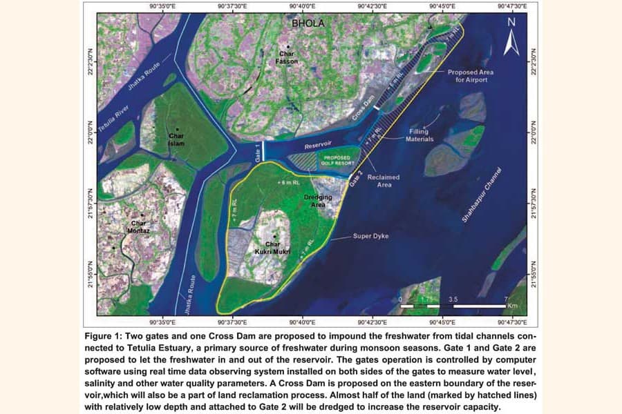
The present study attempts to formulate a plan to manage freshwater resources in the coastal areas of Bangladesh and make it available throughout the year especially during the dry season when the salinity intrusion is at its peak. The goal aims to ensure reliable and adequate provision of freshwater to support equitable and sustainable socio-economic development, environmental sustainability and livelihood security in the coastal zones. The preferred strategy for coastal freshwater aims at improving living conditions, sustaining agricultural and fisheries production, as well as maintaining environmental sustainability. Year-round availability of freshwater for different uses is currently a significant challenge in the coastal area. Considering freshwater flow from Tetulia and the Lower Meghna River, the southern tip of Bhola Island, where the Char Kukri Mukri is located, offers a favorable condition as a location to develop a freshwater reservoir. Freshwater reservoir in coastal zone can be an alternate source of water, a potential which hasn't been explored until this study.
This one-of-a-kind study to harvest freshwater offers a roadmap to build a reservoir at Char Kukri Mukri to supply only a small percentage of total drinking water required in the coastal region. We hope that this effort will lead to further studies to explore other potential areas for additional freshwater harvesting and promote economic growth in the region.
The freshwater reservoir is a unique structure in an estuary to store a portion of freshwater that flows into the ocean during monsoon periods. The reservoir plays a crucial role on the livelihood of the rural and urban coastal population. It has many advantages, such as, there is no need for land acquisition, and no land and forest submergence is likely to happen as in the case of inland reservoirs. They are already put to work with great success in countries like the India, Netherlands, Singapore, China, South Korea and Hong Kong, and are proven to be beneficial to local population and their livelihood.
The concept of the freshwater reservoir enables both normal and major hydrological extremes to be fruitfully utilized for the benefit of local population by storing freshwater in abundance for future use. The freshwater reservoir has the potential to create a new freshwater ecosystem. The reservoir offers an opportunity to promote water sports and promotion of tourism attracting tourists from around the world. There will be an increase in industrial, recreational and freshwater fisheries activity in the reservoir. Roadways around the reservoir, a Golf resort, a domestic airport, freshwater fishing, navigation, renewable energy production and tourism will make the reservoir site a smart township.
Land Reclamation and Development
In addition to exploring the viability of a freshwater reservoir at Char Kukri Mukri, this study is centered-around reclamation of land and its development to allow a continuous southward extension of Bhola. This land, to be reclaimed on the north-eastern part of the Char Kukri Mukri and eastern part of Char Fasson (Figure 1), will provide infrastructural support to tourism industry and will promote economic activities. The reclaimed land will have an area of 9 km2. The land will be reclaimed by constructing a cross dam at the eastern boundary of the freshwater reservoir and a Super Dyke at the eastern and southern boundaries. Land filling up to +6.0 RL (in Bhola side) to +7.0 RL (in the sea side) will mainly be accomplished by dredged material from the western part of the char (inside the reservoir) near Gate 2. The dredging part of this char, which normally inundates during high water, will increase the reservoir capacity. Additional filling material can be had from the lower part of the newly accreted chars, about 3.5 km offshore from the proposed reservoir in the West Shahbazpur Channel.
The new land will be protected from inundation against tide, wave and storm surge with a Super Dyke of +7.0m RL (Figure 2) to be built around the study area. The Super Dyke is also proposed to construct around the Char Kukri Mukri. The height of the Super Dyke embankment is high enough to protect the area from storm surges that frequently hit the coastal zones. Mangrove and mesophytic species (suitable to the coastal zone) will be planted on the seaside of the Dyke to prevent seawater from intrusion. In coastal zone, foreshore afforestation is a proven cost-effective method to dissipate wave energy and reduce wave attacks on dykes during storm surges.

Figure 2: The entire Char Kukri Mukri, the reclaimed land and the reservoir will be protected by Super Dykes along with afforestation to prevent the waves and surges from attacking the Dykes.
The freshwater reservoir will support the population in the region for drinking water, domestic, agricultural and other uses and the tourism industry. The reclaimed land can be used to build a domestic airport and a Golf resort to promote the tourism industry in the area. The airport will serve as a connecting hub between the Char Kukri Mukri and the rest of the country. A potentially high value property, a Golf Resort, may be developed in the char overlooking the reservoir and the West Shahbazpur Channel (Figure 2). People and families, local and foreign, from all across the country can fly to the area and spend their quality family vacations in the resort. This high value property will add significant economic values to the region and thereby to the national GDP. The Airport and other infrastructures in the area will support the operations and economic activities of the nearby Payra Port.
The prospects of leveraging the open access to sea into a major source of growth and development are also being viewed as developing the emerging blue economy of Bangladesh. The efforts outlined in this study are aligned with the Vision 2041 and consistent with the sustainable development goals (SDG 6, 7, 13 and 14) adopted by the UN General Assembly in 2015. The focuses of the sustainable goals are integrated water management, climate resilience, ocean and coastal ecosystem restoration and conservation and sustainable use of resources. The exploitation of the blue economy in Bangladesh is just emerging, and the potential is enormous and the project will provide economic dividends to local businesses and add values to the national GDP. The present study area is expected to provide a safe and enabling environment for other high value developments and improved livelihood of the populations in the area.
Renewable Energy Production
A sustainable development pathway, resilient to disaster and climate change, entails sustainable use of natural resources including solar energy. This study is taking full advantages of all the resources available in the area. Especially the stretches of lands in both northern and southern parts of the reservoir and the area along the Super Dyke circling Char Kukri Mukri, which would be suitable for setting solar panels to generate green energy and provide power to local households and the industries in the area. The tourism industry can be hugely benefited from this low cost renewable solar energy.
Model Simulations and Analysis
An existing operational model called the Bangladesh Coastal Model (BCM) developed by Institute of Water and Flood Management (IWFM), BUET has been applied to assess the impact of cross-dam for building the freshwater reservoir at Char Kukri Mukri. The BCM constitutes three models of Delft3D modeling suite, a) hydrodynamic model, b) morphology model and c) salinity model. All these models incorporate physics-based processes.
Model simulation was conducted for a typical year representing the Ganges, the Brahmaputra and the Meghna river systems' hydrological regime, with a combined peak flow of about 100,000 m3/sec occurred in July and a low flow of about 5,000 m3/sec occurred in February, a conservative estimate for simulating the freshwater availability for the reservoir. The simulation also represents an estimated morphological regime that peaks at 1,600 g/l during high flow period of July and 170 g/l in low flow period of February. Both hydrodynamics and the morphology of the system are simulated and analyzed with or without the gates, cross dam and Super Dyke in the study area. The modeling analyses include the hydrodynamics and morphology of both the monsoon and dry seasons. A careful examination of model simulation results suggests that there is no visible change in the flow field due to proposed intervention in the entire estuarine system. In addition, the model simulations indicate that the change in yearly cumulative erosion-sedimentation due to the intervention is also negligible.
Juvenile Hilsha (Jhatka) Route
A subtle change in velocity and sediment concentration is found in the channel between the Char Montaz and Char Kukri Mukri, which happened to be designated as the preferred migratory route for Juvenile Hilsha (Jhatka) fish. Therefore, a detailed analysis of the hydro-morphology is warranted to make sure the Jhatka migration is not compromised due to the development of the reservoir and land reclamation. The velocity and sediment concentration will be slightly altered due to the closure of the channel between Char Fasson and Char Kukri Mukri for the construction of the freshwater reservoir and land reclamation. However, the Hilsha fish can tolerate a change of velocity and turbidity up to ±30% and ±15%, respectively. In the present study, sediment concentration has been considered as a proxy parameter for turbidity. To assess whether the 'slightly altered' flow and sediment fields will remain within these thresholds, changes of velocity and sediment concentration before and after the intervention are computed at the entry and exit points of Jhatka route. Exceedance probabilities of these two variables during an entire hydrological year are also computed at the same locations to assess whether the existing route will continue to be used by Hilsha fish during migratory season after the intervention is made.
The result shows that change of velocity will mostly remain within the threshold limit throughout the year. There are few instances when the changed velocity crosses the threshold. To quantify this crossing limit, exceedance probability of change of velocity beyond the thresholds of ±30% is computed. It is seen that exceedance probability for velocity is less than 20%, which is statistically insignificant. The sediment concentration is used as a proxy parameter for turbidity. To assess the changed sediment concentration field due to reclaimed land, analyses similar to velocity field are made for sediment concentration field. Results for the sediment concentration field show that the changes of sediment concentration along the Juvenile Hilsha (Jhatka) route due to intervention will mostly remain within the threshold value and the exceedance probabilities are also found to be statistically insignificant. Therefore, no significant change in Juvenile Hilsha (Jhatka) migratory pattern is expected to change due to the intervention.
Availability of Freshwater for Reservoir
Model simulations of salinity distribution in the Meghna Estuary covering the study area, shows that freshwater with almost zero salinity are available near the reservoir during June through October (5 months). Other seasons are not quite suitable for storage due to elevated salinity concentration in the water. Therefore, the size of the reservoir should be big enough to support the freshwater needs in the area. Assessment should be made for forecasted water demands in the area for the entire year so that reservoir operation is designed accordingly.
It is estimated that a total of 1,200 billion m3 of freshwater flows into Bangladesh territory every year through international rivers (BDP 2100); the quantity of water being discharged in the Bay of Bengal, however, is not well documented. Considering a big percentage of this volume flows through the estuarine systems of Bangladesh, an insignificant amount of freshwater is probably being used in the coastal area before it's being discharged into the Bay of Bengal. Freshwater reservoir can be an effective means to trap and store this unused freshwater. On the other hand, year-round availability of freshwater for different uses is currently a significant challenge, particularly in the coastal zone. Considering freshwater flow from Tetulia, southern tip of Bhola Island, where the Char Kukri Mukri is located, is a location where development of freshwater reservoir is technically and economically more attractive.
Volume of freshwater reservoir by taking water level at MSL in the proposed location is estimated to be about 23 million m3. This will cover only a fraction of total domestic freshwater demand in the coastal area. The surface area of the reservoir is about 12 sq. km.
Conclusions
The present study has formulated a unique concept to build a freshwater reservoir, a domestic airport on the reclaimed lands, a Golf resort, solar power generation and other infrastructure to develop a smart township at Char Kukri Mukri, the southern tip of Bhola. The freshwater reservoir will support the population in the region for drinking water, domestic use, agricultural and other uses including tourism. Volume of freshwater reservoir is estimated to be about 23 million m3 and the surface area is about 12 km2. The reservoir has the potential to create a new freshwater ecosystem. The reservoir will provide an opportunity to promote water sports, Golf and promotion of tourism; attracting tourists from around the world. There will be an increase in industrial, recreational and fisheries activities around the reservoir. Roadways, solar green energy production, freshwater fishing, navigation, Golf resort and tourism is expected to make the reservoir site a smart township.
The airport will help develop connectivity between Char Kukri Mukri and the rest of the country. The prospects of leveraging the open access to sea into a major source of growth and development are also being viewed as developing the emerging blue economy of Bangladesh. The efforts are aligned with the Vision 2041 and consistent with the sustainable development goals (SDGs 6, 7, 13 and 14) adopted by the UN General Assembly in 2015. The exploitation of the blue economy in Bangladesh is just emerging, and the potential is enormous and the project will add economic value to the national GDP. The present study area is expected to provide a safe and enabling environments for other developments including the nearby Payra Port and improved livelihood of the populations in the area.
The preferred strategy for coastal freshwater aims at improving living conditions, sustaining agricultural and fisheries production, as well as maintaining environmental sustainability. This study is centered-around reclamation of land and its development to promote economic activities and provide safe and enabling environments for other developments and improved livelihood. The area of the reclaimed land is estimated to be 9 km2. A domestic airport and a Golf resort will be built on this reclaimed land. This airport will serve as a hub of connectivity across Bangladesh.
The Super Dyke to be built around the study area along with the mangrove and mesophytic species (suitable to the coastal zone) on the seaside to prevent seawater from intrusion. This study is taking full advantages of all the resources available in the area, especially the stretches of land in both northern and southern parts of the reservoir and around the Char Kukri Mukri, which would be suitable for setting solar panels to generate green energy.
The proposed reservoir, reclaimed land and Super Dyke will not affect the preferred migratory route for Juvenile Hilsha (Jhatka) fish. Modeling analysis suggests that the velocity and sediment concentration changes will remain within the tolerable limit and migration of Jhatka fish will not be affected.
Recommendations
The present study is aligned with the Vision 2041 and consistent with the sustainable development goals, SDGs 6, 7, 13 and 14. If the project is implemented, Char Kukri Mukri and the surrounding area can turn the water challenges to opportunities and reap significant economic dividends. Therefore it is strongly recommend that the BWDB initiate a feasibility study immediately and implement the project as soon as possible.
The sediment management of the reservoir and its inlet and outlet could be a challenging operational issue and it is highly recommended that a comprehensive plan to manage sediments including periodic bathymetric survey and dredging program be formulated in the feasibility study.
Since the reservoir will hold the nutrient-rich river water for a significant period of time, aquatic plants such as algae and water hyacinths may pose a significant threat to water quality. Therefore a periodic monitoring of water quality parameters such as N, P, Si, C, BOD and COD should be conducted. Moreover, water levels and salinity on both sides of the gates should be measured every 30 minutes, especially during the gate operations. If the water quality doesn't meet the criteria of human consumptions or other uses, the contaminated water can be flushed out through the gates. Detailed operational procedures should be outlined in the feasibility study.
To guide future plans for building additional freshwater reservoirs in other parts of the coastal areas, it is imperative to operationalize the knowledge gained from this study. It is recommended that BWDB scale-up the knowledge gained and develop more refined and resilient solutions towards the development and operation of freshwater reservoirs elsewhere in the country, either in coastal or fluvial flood plain areas.
Engr. Md. Mahfuzur Rahman and Dr. Shamal C. Das are from Bangladesh Water Development Board, Dhaka and Dr. Quamrul Ahsan, Dr. Anisul Haque, Dr. Munsur Rahman and Dr. Shampa from the Institute of Water and Flood Management (IWFM), BUET, Dhaka
quamrul@icloud.com